Monday, August 21, 2017

Smoke on the Eclipse

Hopefully, lots of you got out to enjoy the eclipse today. As we were watching the eclipse from our Atmospheric Science campus in Fort Collins, we were looking around at how much the sunlight was dimmed. We saw that there was definitely some smoke visible to the north as shown in the following pictures. The second photo was taken during the maximum eclipse time here.

Looking north from the Atmospheric Science Building in Fort Collins, CO at 11:16 AM and 11:46 PM.

 The Colorado Department of Public Health had this smoke advisory out (https://www.colorado.gov/airquality/colo_smoke.aspx):
COLORADO SMOKE OUTLOOK:
Monday, August 21, 2017, 2:30 PM MDT

Smoke from wildfires in the northwest United States and western Canada is being transported into Colorado. The influence of this smoke is expected to produce areas of haze, particularly in northern Colorado, however these conditions are possible throughout the state. Significant health impacts are not anticipated, however, unusually sensitive people should consider reducing prolonged or heavy exertion on Monday and Tuesday. 

Light to moderate smoke is also possible near prescribed fires and small wildfires around the state. 

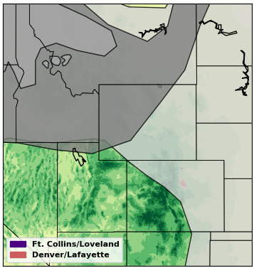
Unfortunately, the Fort Collins PM monitor does not appear to have any data available since Saturday morning, so I cannot tell you what the impact is on surface air quality here in Fort Collins. The Greeley monitor does show PM concentrations that were elevated (especially overnight), but there's been lots of variability, so it's difficult to tell if wildfire smoke is the culprit.
PM2.5 concentrations at the Greeley Hospital for 18th August- 21st August, 2017. Data from: https://www.colorado.gov/airquality/.
And this is what the MODIS satellite image looked like (the overpass was right during the eclipse!):
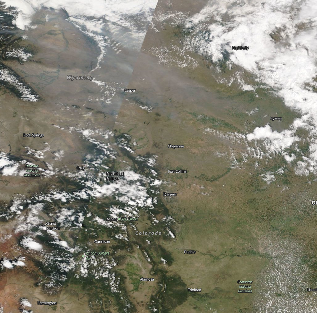
MODIS Terra True Color Image from August 21st, 2017. Retrieved from  https://worldview.earthdata.nasa.gov.
But, never fear, we can still look to the HMS product! The HMS smoke and fire product did show that we are getting some smoke from fires in the Pacific Northwest. The plume seems to be covering much of northern Colorado, so it could definitely be influencing the surface air quality!


Again, happy "eclipse of the century" day. Hope you enjoyed it and kept your eyes safe!

Monday, August 14, 2017

Smoke in Fort Collins August 8-11, 2017

It was cloudy and rainy a lot last week, so you may not have noticed all the wildfire smoke in the air. Since I work near the foothills, I can use them as a quick visibility reference. On Tuesday (August 8th), they were definitely looking a little hazy (as you can see in the picture below), and I got several messages asking if it was smoke.

Looking northwest from CSU Atmospheric Science Campus August 8, 2017 at 5:30 PM. 

We checked and noticed that PM2.5 concentrations were elevated that day, peaking around 25 ug/m3.

Hourly PM2.5 concentraions at CSU Facilities for August 8th - August 12th, 2017. Data taken from https://www.colorado.gov/airquality/.

As you can see from the HMS below, we were getting smoke from the Northwest pretty much all week. I noticed haziness again on Friday and took this picture from the roof of the Atmospheric Science building (out on Laporte Ave in west Fort Collins) looking north. Comparing this to the time series, we can see that concentrations had actually decreased from earlier that morning when they had built up to 17 ug/m3

Looking north from the Atmospheric Science building in west Fort Collins at 1:30 PM on Friday, August 11, 2017.

The smoke plumes seemed to be moving around and over us a lot up here in Fort Collins, but the smoke seemed to not make it down to Denver as often. Thankfully, concentrations in Fort Collins did not get as high as on Tuesday for the rest of the week, and you can also that the afternoon rains kept helping clear the air. It was not until Friday evening when I saw another cool, really red sunset (unfortunately all my pictures were pretty blurry). There were some local fires on August 10th, but they did not seem to produce smoke plumes that stood out in the HMS product from the smoke transported from the Northwest.

HMS Smoke Products August 8th AM, August 8th PM, August 9th AM, August 9th PM, August 10th AM, August 10th PM, August 11th AM, and August 11th PM. 

Looks like the smoke is skirting past us today (Monday, August 14th), but we will see what the rest of the week holds!

Thursday, August 10, 2017

Smoke in Colorado August 1-4, 2017

While I was in Montana (which was completely blanketed in smoke the whole time I was there), Colorado also got some wildfire smoke. There are lots of fires in BC, WA, ID, and MT, so it is difficult to tell exactly where all the smoke came from originally. However, it got here and did degrade the air quality in Fort Collins. You are probably noticing an overall theme, which is that most of our significant particulate pollution events are due to wildfires, both from local and distant fires. Thus, most of these blog posts are about wildfire smoke. Unfortunately, I do not have any cool sunset pictures as I was away last week, but I will show what the impact was on our PM2.5 concentrations and the satellite view of smoke over northern Colorado.

We can see from the time series above that PM2.5 concentrations were slightly elevated on August 1st - August 4th, which does correspond to smoke over the area as shown in the plots below. There was a lot of variability as the wind shifted smoke plumes around. Another thing to remember when comparing the time series to the plots below, is that these smoke plumes are determined from satellite images. Satellites see the whole atmosphere and not just the surface. Satellites "see" smoke over northern Colorado on many days when there is no corresponding increase in surface PM2.5 concentrations. Sometimes smoke can be lofted above our heads (especially when it has been transported a long way); visibility may be impacted but not necessarily our health.

HMS Smoke Plumes over northern Colorado on August 1st AM, August 1st PM, August 2nd AM, August 3rd AM, August 4th AM, and August 4th PM. 

You could also see the smoke in the MODIS (true color) satellite image over Colorado on August 2nd and 4th. The bright white is cloud and the gray "wisps" are smoke. You can probably see why it might have been difficult for someone on the ground to tell smoke from the clouds with it all layered together!

MODIS Terra true color image from August 2nd and August 4th, 2017. Retrieved from https://worldview.earthdata.nasa.gov.

Monday, August 7, 2017

A Montana Vacation in Smoke

So, a little background on me: I was born in Montana and still have family up there. My husband and I love it up in the Flathead Valley (near Glacier) and try to vacation there often. So, we decided to spend a week visiting friends and family before the semester starts back up.

Looking northwest from Main Street in Kalispell (technically, Sweet Peaks) on Tuesday, August 1st at 9 PM. The super red sunset was from all the smoke in the air.

Unfortunately, Montana has been really hot and dry this summer, and there are wildfire everywhere. Since smoke exposure is bad for your health, we didn't hike or camp like we were planning. We still had an amazing time and saw some sweet sunsets (see pic above), but the smoke is a sad situation and definitely reduced the visibility of all the beautiful scenery (see pic below). Another problem is that it isn't usually hot for so long, so a lot of people don't have air conditioning, and the smoke makes it indoors.
Looking north from Columbia Falls at Whitefish Mountain on (left) Tuesday, August 1 at 11 AM,  (middle) Thursday, August 3 at 6 PM, and (right) Saturday, August 5 at 10:30 AM. The mountains kept appearing and disappearing!

So, I'll give you an idea of the conditions there. Most of the fires are in western  Montana, around Missoula (although by the end of the week, we were getting smoke from Idaho, Washington, and British Columbia as well). We drove up through Seeley Lake on Saturday, July 30, 2017. It smelled like smoke and my eyes were burning. The Rice Ridge Fire (https://inciweb.nwcg.gov/incident/5414/) was burning just west of Seeley Lake. They were on mandatory evacuation watch all last week, the lake was closed for recreational activities, and lot of the hiking trails were completely closed. It is still only 10% contained. Probably didn't help that they had to suspend aerial firefighting last week on Wednesday because someone was flying a drone.

HMS Smoke Plumes and Fires for July 30th, July 31st, August 1st AM, August 1st PM, August 2nd, August 3rd AM, and August 3rd PM.

Concentrations definitely reached the unhealthy level for many towns in Montana. From the HMS plots, you can see smoke covering most of the state pretty much everyday of our vacation. It smelled like a campfire outside a lot of the time. I took allergy medicine everyday and had pretty itchy eyes. I had filled my inhaler prescription before I left, but luckily, I didn't have to use it (probably because we didn't do any vigorous outdoor activity). Anyway, here were the concentrations in the Flathead Valley, not nearly as high as down in Seeley Lake or other towns south of where we were (Columbia Falls/Whitefish/Kalispell), but still much above normal.

PM2.5 concentrations recorded for the Flathead Valley monitor for July 30 through August 4, 2017. Data from http://svc.mt.gov/deq/todaysair/.