Leaving work Wednesday night at around 7 PM MST, I noticed the foothills looked a little hazy and the sun was a
little more orange.
 |
| Looking west from the Department of Atmospheric Science parking lot at 6:56 PM MST on July 5, 2017. |
I scooted home and took this next picture about 10 minutes later. You can see the sun is even more red-orange!
 |
| Looking west from Galway Drive in Laporte at 7:07 PM MST on July 5, 2017. |
We are used to lots of pretty pink sunsets here in colorful Colorado, so what's causing me to stop and take these pictures? First a little background on why we get colorful sunsets. At sunset, the sun is lower in the sky, causing its rays to travel through more of the atmosphere and experience more scattering of blue light. This leaves a higher proportion of red light. However, these orange-red sunsets are a bit different. These are indicative of more small particles higher up in the atmosphere that are just the right size to scatter even more of the blue light, leaving the sky a beautiful red-orange.
What is the source of these small particles? Unfortunately for our health, they are smoke. Now, I am sure we have all been exposed to quite a bit of smoke the last few days with all the fireworks (especially if you live in Laporte like me!), but this smoke is likely from a wildfire. While the Peak 2 Fire (https://inciweb.nwcg.gov/incident/5321/) near Breckenridge was all the talk Wednesday, my guess would be that this smoke was from either the Keystone Fire (https://inciweb.nwcg.gov/incident/5309/) west of Albany, Wyoming or the Mill Creek Fire (https://inciweb.nwcg.gov/incident/5330/) northwest of Hayden, Colorado.
The Hazard Mapping System (HMS) smoke product showed several different smoke plumes in our vicinity this week. For the last two days (July 6-7th), smoke pretty much blanketed the state.

 |
HMS Smoke Plumes over northern Colorado for July 3-7, 2017.
|
I noticed this smoke on the morning of July 7th because I had hoped the air would be cleaned out after the rain the previous day. No such luck. While the sky was pretty blue, I could see some smoke over the foothills as shown in the following pictures.
 |
| Looking northwest from the CSU Department of Atmospheric Science Campus at 10:58 AM on July 7, 2017. |
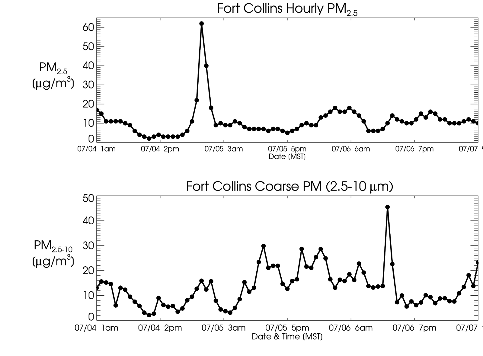
We can look at the surface measurements of PM
2.5 in the following time series and see that concentrations were about double the "normal" concentrations in Fort Collins on the evening of Wednesday, July 5th and into the morning of Thursday, July 6th. Concentrations did not reach the "Unhealthy" level, as most of the smoke was probably lofted above the surface. With all the different fires, it seems that we have had smoke every day this week.
 |
Time series of hourly PM2.5 (top) and coarse PM (bottom) measured in Fort Collins for July 4th through the morning of
July 7th, 2017. |
There are two other interesting PM increases due to different sources on the time series plot. The 4th of July fireworks led to a really large increase on Tuesday night, and dust lofting before a storm on Thursday shows up in the coarse PM. A good reminder that there are lots of different sources of PM!